Squawkr: never miss a good flying day
Our new flight-planning app brings airfield weather, runway wind and restriction areas into one clear view. The first release is now open to pilots.
Role
Product creation
Industry
Aviation
Duration
Launched September 2026

We’ve launched Squawkr, a flight-planning app that brings airfield information, local weather, crosswind and restriction areas together. It opened to the public on 19 September 2026, with its core functionality available for free. But this initial release is just the beginning.
Our vision is to create a suite of software and hardware devices that aid pilots before, during and after their flights. The first app starts with making pre-flight information easier to understand. Over time, we want Squawkr to support the wider experience of flying, bringing useful tools into the moments when pilots need them.
The idea is simple: less decoding, more flying. The information pilots need is spread across several sources, and much of it arrives as METAR, TAF and NOTAM code. Squawkr collects it and turns it into a view that is easier to read, while keeping the original source text available to check.
A clearer picture before you fly
Open an airfield and you can see its runways, a true-scale 3D view and satellite imagery. Squawkr suggests the runway that best suits the wind, shows the headwind or tailwind and crosswind for every runway, including gusts, and visualises wind flowing across the runway in the 3D view.
The latest METAR is decoded into flight rules, wind, visibility, cloud base, temperature and pressure. Cloud layers are drawn on an altitude chart, and TAF forecasts become a timeline of the conditions ahead. Raw METAR and TAF remain available exactly as issued.

Airspace information you can inspect
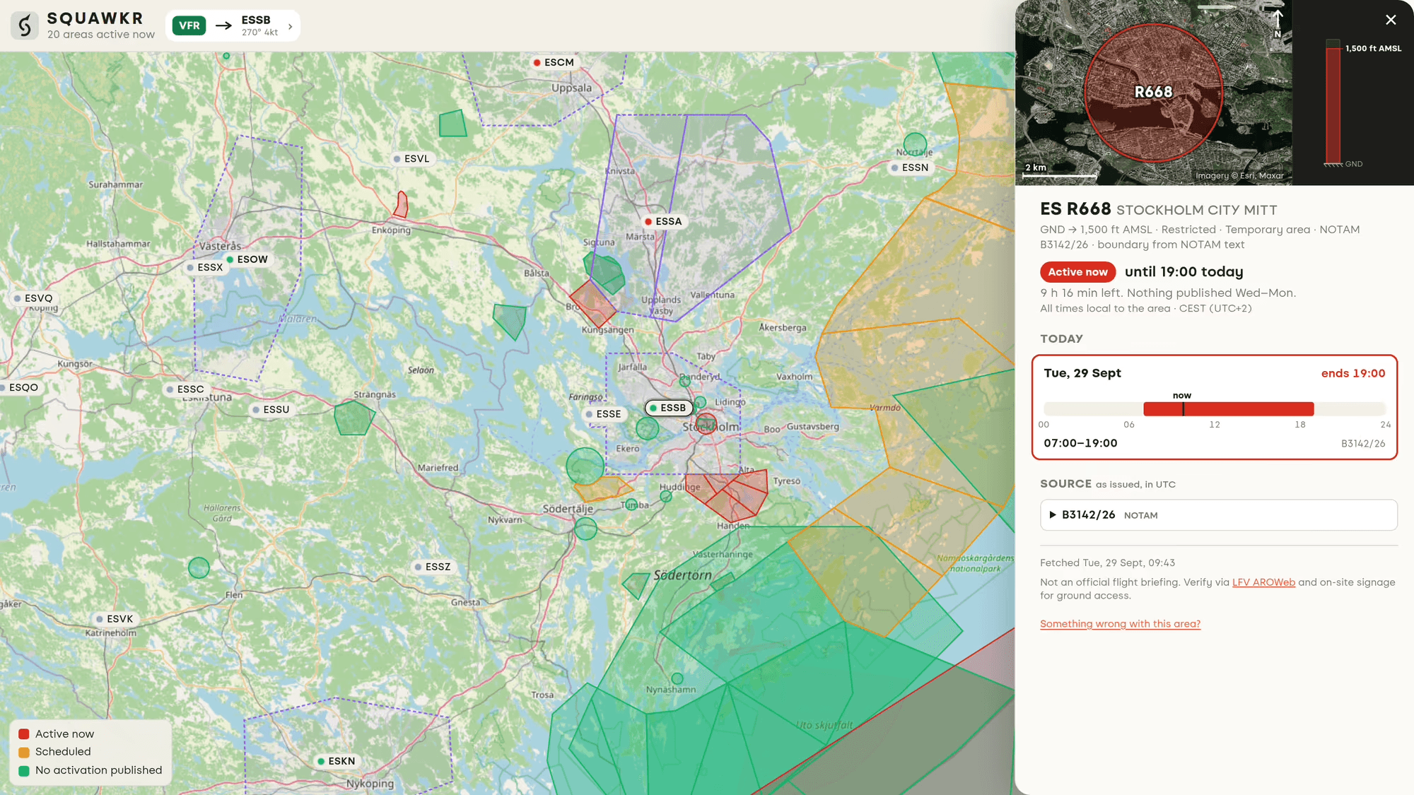
Restriction and danger areas are colour-coded on the map: red for active now, amber for an activation scheduled later today or this week, and green when no activation has been published.
Tap an area to see its vertical limits drawn to scale, activation windows for the next seven days and the source NOTAM. Where areas overlap, Squawkr lists them together and draws their heights on a shared scale. In Sweden, it also shows control zones, including their class, limits, sectors and reporting points.
Designed for a quick check on your phone
Squawkr runs in a browser on your phone or computer. Add it to your home screen and it opens full screen, without a separate app-store installation. Search airfields by name, ICAO or IATA code, search restriction areas by designator or place, and share a direct link to an airfield or area.
Times are shown in the local time of the airfield or area, with the time zone alongside them. Each answer shows the age of its data. If a source is slow, Squawkr displays its stored copy while refreshing in the background; stale data and copies shown without coverage are labelled.
You can open five airfields and areas without an account. After that, a free account is required. Sign-in uses a six-digit code or an email link rather than a password, and the app remembers where you last looked.

Other projects

Tourism + Digital
Helping hotels and destinations with digital strategies to develop their businesses

Fjord Stockholm
A study of team and culture that led to the growth of the best design studio in Stockholm

Ö-Chips
Don't be nuts, eat potato chips! Reimagining potato chips for the hospitality industry!

CNN Mobile
Design, development and lauch of the International CNN mobile website and mobile application